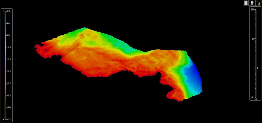
Ship Admiral Magnaghi under the command of the frigate captain Ivano De Guida has just completed the preparatory data acquisition activity for updating map No. 24, "from Roccella Ionica to Capo Rizzuto", of the national cartographic portfolio.
In recent years, the unit has dedicated three hydrographic campaigns to perfecting this important work in an area of great interest for tourism, fishing and maritime traffic to and from Crotone.
The effort of the staff of the Hydrographic Institute embarked for the occasion involved both the execution of a three-dimensional mapping of the seabed, also conducted with the use of acoustic sensors installed on the two hydroboats of Nave Magnaghi, and the use of GNSS receivers for functional topographic surveys for the subsequent reconstruction of the coast line and the determination of conspicuous points.
In the coming months, the collected data will be validated, processed and certified by the hydrographic personnel embarked on the flagship of the national hydrographic fleet - which in addition to Nave Magnaghi it is made up of catamarans Arethusa e Galatea, as well as the NATO Alliance and Leonardo Units that the Navy leads and co-employs with the maritime experimentation and research centre NATO based in La Spezia – before later being shared with the Hydrographic Institute of the Navy (IIM). As the State Cartographic Body responsible for the national hydrographic service and for the production of all the official nautical documentation relating to the Italian seas, the IIM will insert the large amount of data collected in the respective databases, making them available for the production of nautical documentation such as nautical charts (the update of chart no. 24) and publications such as pilot books or the list of lighthouses and lanterns essential for planning and conducting navigation in safety. The data, collected with the highest possible resolution, will also be useful for longer-term scientific considerations and studies, such as monitoring coastal erosion, changes in seabed morphology or marine flora.