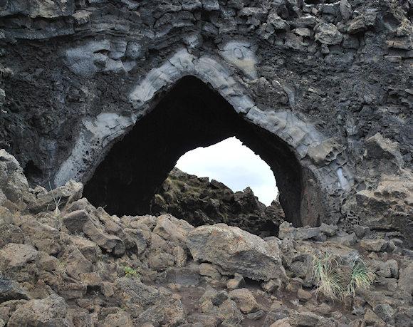
From 7 October 2023, the Gaza Strip became the Dimmu borgir of the Middle East, perhaps of the Planet. What does Iceland have to do with Palestine, you might say.
It's true, Dimmu borgir it means "dark fortress" and is the name given to an Icelandic volcanic formation which, according to local legends, constitutes the entrance to hell (photo).
That inhospitable portion of land nestled in Israeli territory which is the Gaza Strip, from a military point of view, we can consider it to all intents and purposes a fortress, both for its small size (360 square kilometres, the surface area of a town like Enna, so to speak), and for the level of urbanisation, which features high buildings and low buildings leaning against each other, so as to create a maze in which more than 2.226.000 are crammed1 inhabitants (Enna has 25.000 and much larger Italian municipalities still have fewer). Of these, over 1.400.000 are Palestinian refugees.2 Nonetheless, today more than ever, assimilation at the entrance of thehell Unfortunately, it appears to be effective. It is both for the living conditions of the people who live there and for what a large-scale military action inside it would entail in terms of combat.
I tried my hand at studying a Intelligence Preparation of the Operating Environment (IPOE) expeditious to try to imagine on the one hand what the implications of entry with the ground forces could be Israeli Defense Forces (IDF) in a territory such as the one briefly described and on the other to understand how the Hamas terrorists acted to launch the attack that the Israelis have now defined as their "September 11th".
Let's start from the Area of Operations, limiting it first to the Gaza Strip and then to the inhabited area of Gaza, to examine some more detailed aspects.
The width of the front extends for approximately 40 km, the average depth of the Strip is approximately 9 km. In this area there are five main inhabited centers, substantially aligned and located in a north-west/south-east direction, as follows:
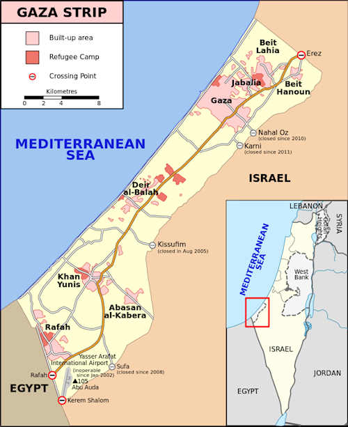
Gaza City, with the suburbs of Jabalia, Beit Lahia and Beit Hanoun located to the northeast;
-
Deir al-Balah;
-
Khan Yunis and Abasan al Kabira;
-
Rafah, a town on the border with Egypt, half of which is occupied by two refugee camps. To the south of the country is Yasser Arafat International Airport, which has been unusable since 2005.
In addition to the inhabited areas and the former airport, others k-terrain are represented by the seven gates distributed along the barrier built under the leadership of Israeli Prime Minister Yitzhak Rabin, six of which are located between the Strip and Israel and one between the Strip and Egypt. The barrier, designed for security reasons, consists of barbed wire fences with posts, sensors and buffer zones along the land bordering Israel; in steel or concrete walls along the border with Egypt.
Of the original seven gates, only three remain open today. After Israel imposed the blockade in 2007, all the crossings were gradually closed except for those in Erez and Rafah, designated for the movement of people, and the Kerrem Shalom crossing, designated for the transport of goods.
The Rafah crossing is the only one that allows transit between Egypt and Gaza and, therefore, represents a vital link between Gaza and the rest of the Arab world, especially after Israeli forces destroyed Yasser Arafat International Airport.
The Erez crossing, placed under the control of the Israeli army, is located in the north of the Gaza Strip and is the only border crossing that allows Palestinians from Gaza to travel to the occupied West Bank without passing through Egypt or Jordan.
The Kerrem Shalom crossing is located near the borders between Egypt, Gaza and Israel; it is mainly used for commercial movements between the Gaza Strip and Israel and, occasionally, as an alternative to the Rafah crossing for the transit of people.
Since 2007, Israel has banned a long list of goods from entering Gaza, including items it considers dual use, i.e. suitable for civilian use, but which could also be used for military purposes.
The remaining gates were closed by Israel again for security reasons; they are Karni Crossing, Sufa Crossing, Nahal Oz Crossing and Kissufim Crossing. The latter is located east of Khan Yunis and Deir al-Balah and was closed in 2005 after Israel's disengagement from Gaza.
It is therefore understandable that from a tactical point of view, the control of these accesses to the Gaza Strip is fundamental for the entry into that territory with large quantities of troops. Similarly, the road arteries are of vital importance as they constitute the possible attack lines towards the objectives represented by the inhabited centres.
 I will indicate the three main ones, which allow the passage with columns of tanks both due to the dimensions of the roadways and the conditions of relative safety that can be established in the movement phase for contact. The first is thehighway 25 which, having crossed the check point of Nahal Oz, takes the name of "Baghdad" and flows into the heart of the city of Gaza; the second is the Kissufim Road, extension of highway 242, which leads to the heart of the Strip, in sprawl urban area that runs longitudinally along its entire length. It is no coincidence that the Kissufim crossing has already in the past been used as an entry point for Israeli tanks and military vehicles during military incursions into Gaza;3 the third would behighway 10 which arrives in Rafah, along the border with Egypt. And this is a problem.
Considering that the Egyptians would not look favorably on columns of Israeli military vehicles on their border, Israel could then exploit the buffer zone 200-300 meters wide and 14 km long, known as the "Philadelphi Route". The option of entering the Strip using this last route is not practicable; this is the reason for the campaign psy ops conducted by the book with leaflets inviting the Palestinian population to evacuate the area by moving south, to allow a battle against Hamas that does not involve innocent civilians. Therefore, it would be the "optimal" solution, if this term can be used in such a context, it would give these poor people the opportunity to receive humanitarian aid through the Egyptian corridor, in the ways and times in which Cairo will allow.
Once the center of the Strip has been reached through Kissufim, therefore, the Israeli units should carry out a longitudinal movement along the Salah Al Deen highway, in a south-west direction to reach Rafah. A somewhat arduous task considering the type of urban density described above and the difficulties that infantry and armored maneuver units would encounter, which would be constantly engaged in long and exhausting house-to-house combat.
Let's also consider just the town of Gaza, whose plan is presented according to what is called the "satellite" model. This consists of a cluster central and larger than buildings from which streets structured like a spider's web lead to other smaller urban areas (in our case, the suburbs mentioned previously). Communication lines tend to gravitate around the central and larger urban area. Both Israeli forces and Hamas know well what it means to engage in urban combat. Hamas terrorists, in particular, have certainly benefited from the lessons learned from qualified instructors, be they Iranian or, indirectly, even Russian.
 The Battle of Grozny fought during the Second Chechen War in 1999 (photo) is textbook. The experience lived by the Russians first-hand has become a shared heritage, to be passed on to all the fighters who, in various capacities, are trained by them. And in Syria the Kremlin provided advice and training to the brigade's Palestinian militiamen Liwa al-Quds, hundreds of them employed to fight and to support links with the forces of elite Syrians and with the Ba'th party.4 I would not rule out learning through osmosis of knowledge between the various Palestinian organizations at all.
The ambitious end state outlined by the Israeli Defense Minister, i.e. guaranteeing Israel's security from the threat coming from Gaza "definitively", necessarily implies the conduct of an invasion of the Strip, with all the consequences of the case.
It must be said, first of all, that combat in inhabited centers presents high difficulties for the maneuver of armored troops. These absolutely cannot move without the support and protection of the infantry who, mainly on foot, must guarantee safety to allow the vehicles to proceed among the dangers of the urban environment.
Urban combat develops on five levels: street level, intra-building, building roofs, aerial dimension and, last but not least, underground. It is unknown how many tunnels there are today and the IDF5 he carried out many interventions to destroy them. Numerous operations were conducted by the Israeli military to dismantle the network, and houses where access to the tunnels was discovered were systematically demolished. I want to remember the Operation Rainbow of May 2004, aimed in part at destroying underground tunnels and damaging terrorist infrastructure in the area. Nonetheless, Hamas continued to use them for military purposes.
The most sensational episode dates back to 2006, when an Israeli soldier, Gilad Shalit, was kidnapped and freed after five years thanks to a prisoner exchange involving over a thousand Palestinian prisoners. Also in 2006, Hamas number two, Ismail Haniyeh, declared that the group had built a network of tunnels twice as extensive as the one used by the communists against American soldiers in the Vietnam War.6 The network of tunnels under Gaza, however, has not only been extended into Israeli territory.
The Philadelphia Route, mentioned previously, built precisely to prevent the illegal circulation of materials (including weapons, ammunition and drugs) and people between Egypt and the Gaza Strip, has however been circumvented by the Palestinians who, over the years, have created a dense network of underground tunnels for smuggling, right in the Rafah area.
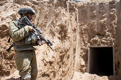
Over the years, therefore, Hamas has exploited the tunnels between the Strip and Egypt to illegally import weapons and armament components with the help above all of Iran and Syria and thus managed to significantly expand the own arsenal. Due to its characteristics, the underground offers great opportunities and hides great dangers in combat.
In light of what has been said so far, it should be almost intuitive to understand what risks the Israelis must face in occupying Gaza. The problem is not only in being able to conquer the towns one by one, but also in maintaining possession of them. The large maneuver units of the IDF are divisional level and predominantly armored divisions. These, obviously, in their workforce can count on the necessary infantry component I mentioned, represented by light (motorized) and heavy (mechanized) infantry brigades. In Israeli tactics, I repeat, the main role is played by the tank component, trained to maneuver in the large spaces offered by combat areas in open and predominantly desert fields. That's not the case.
The model becomes more complicated due to the rubble caused by the intense bombing on the Strip, which makes the movement of combat vehicles even more difficult, as a result of the so-called blocking: due to narrow spaces, a limited road network and the presence of obstacles, the mobility of units on vehicles, but also on foot, is significantly degraded.
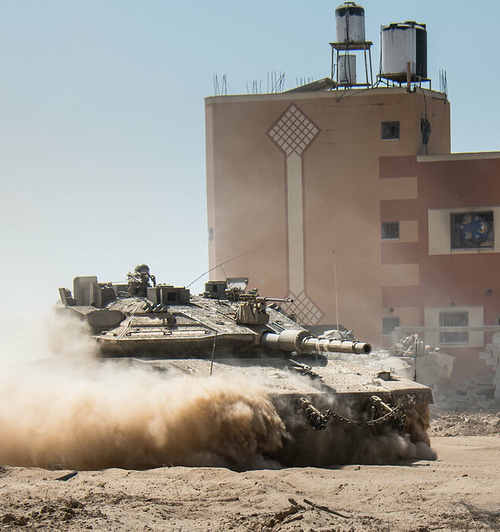
Here then are the tanks Merkava, which in all their versions have always represented the "rams" of the army of Jerusalem and which even today must spread into the Strip, present some vulnerability.
It is also true that the IDF has long found itself under the threat of anti-tank missiles, mainly of Russian/Soviet manufacture. In 1973 they were i sagger used by Egyptian infantry in the Suez area; in 1982, in Lebanon i Merkava Mk I also had to deal with RPGs. Then came the missiles Bassoon, employed by Hezbollah on behalf of i Merkava Mk II in the mountainous and urbanized context of southern Lebanon. The growing threat to Israeli vehicles led to the development of updated versions of the tank: the Merkava Mk3 III and the new and improved Mk IV version introduced into service in 2004. In combat the Israelis had to test on their own armor the subsequent innovations of the Russian and Iranian-produced anti-tank missiles: the Kornet-E 9P133; The Metis-M 9M131; The Konkurs 9K113; The Bassoon 9K111, the RPG-29, among others.
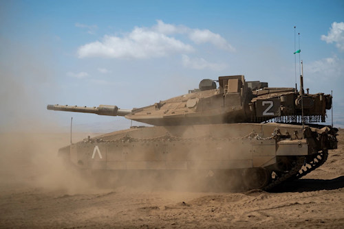
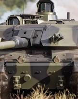
We come to the present day, when the Ministry of Defense and the IDF announced the entry into service of the fifth generation tank, the Merkava Barak, the result of five years of development. The first examples were assigned to the 52nd armored battalion of the 401st armored brigade.
Some data on the characteristics of the wagon:
Barak tanks are equipped with “an extensive reliable sensor infrastructure” to detect targets, and intelligence information can be shared between the tank and other units of the armed forces, which will be “a real revolution on the battlefield” . “The Barak tank will strengthen enemy detection capabilities and allow fighting against an enemy with reduced identification and in all combat scenarios, on the current and future battlefield, against the set of threats that exist for forces maneuver,” the ministry declared. These systems allow the military to fight while the tank is completely sealed, with no doors open, unlike previous Merkava designs where the tank commander is more vulnerable to sniper fire or less able to see his surroundings.7
We hope so for the crews who will have to use them.
Having said that, another observation concerns the quantity of forces to be committed to a ground operation of this kind. For the attack on a sector and with the characteristics of the one indicated at least two divisions are necessary, possibly parachute battalions should also be included more for the type of technical-tactical procedures than for use on in-depth objectives, since this is truly limited. The real problem, however, is consolidation, once the objectives have been achieved.
It is necessary to have at least another infantry division for widespread control of the occupied area, in such a delicate phase. All this could imply the need to release units from the West Bank sector, where Israel currently has the greatest concentration of its army. Alternatively, it can continue to raze the entire area with indiscriminate bombing, so as to reduce the level of threat to be faced as much as possible.
In any case, a bloodbath, on one side or the other. Or both.
1 Palestinian Central Bureau of Statistics, 2023. https://www.pcbs.gov.ps/site/lang__ar/881/default.aspx#CensusA.
2 United Nations Relief and Works Agency for Palestine Refugees in the Near East. https://www.unrwa.org/newsroom/news-releases/gaza-strip-number-displaced....
3 M. Humaid, The seven border crossings of Gaza, Invictapalestina, 24/06/2022. https://www.invictapalestina.org/archives/46135.
4 N. Cristadoro, Missiya vypolnena! Mission accomplished! Russian armed forces in the Syrian campaign (2015-2019), Il Maglio Editions, 2020.
5 Israel Defense Forces.
6The tunnels under the Gaza Strip, 1st Post, 18/05/2021. https://www.ilpost.it/2021/05/18/tunnel-hamas-striscia-gaza/.
7Israel: fifth generation armored tank unveiled, Infodifesa, 19/09/2023. https://infodifesa.it/israele-svelato-carro-armato-quinta-generazione/.
Photo: Chmee2/Valtameri / Gringer / Israel Defense Forces / Svm-1977