The area is characterized by a particular rhythm of the tides and subject to important evolutionary dynamics, such as the lowering of the soil (subsidence), the rise in sea level (eustatism), the contribution of river sediments and the dynamics of the waters marine along the coast.
The data acquired, valorised and sent to the Hydrographic Institute of the Navy (IIM) will be used to produce and update the official nautical documentation, indispensable for all navigators and the safety of navigation.
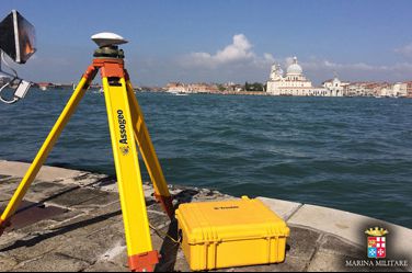 Galatea ship with its crew, each year carries out hydrographic campaigns, lasting about six months, aimed at updating the nautical documentation, verifying the seabed, studying the chemical-physical parameters of the waters and the characterization of the seabed, also in collaboration with research institutions and institutes in the field of multi-purpose and "dual" activities.
During the stop in the Venice Arsenal, the commander, vessel lieutenant Alessio Sabbatini, accompanied by the hydrographers on board, visited local research centers, ISPRA (Higher Institute for Environmental Protection and Research) and CNR-ISMAR (National Research Council - Institute of Marine Sciences), sharing nautical information useful for conducting reciprocal activities and at the same time useful for consolidating collaborative relationships.
Source: Military Navy