The collaboration project begun in 2018 between the Hydrographic Institute of the Marina and the Catholic University for the study and research of the seabed of Lake Garda and the Subalpine Lakes, called "Accurate Climate Change Unified Risk Assessment for Territory and Environment in sub-alpine lakes (ACCURATE)", for the execution of the bathymetric survey of the entire Lake Garda for the development in the scientific research field of the model-numerical analysis of the morphology of the seabed, aimed at creating an accurate simulation of the motion of the waters of the aforementioned basin in relation to climatic events extremes or danger to the population.
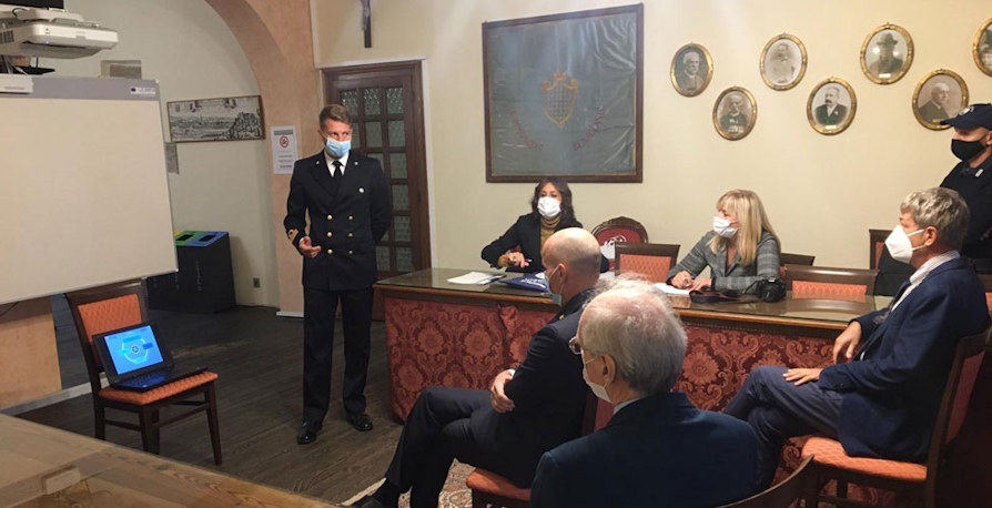
On October 15 in the Council Chamber of the Municipality of Lazise, the hydrographic expedition leader tv Roberto ALEO presented the results obtained during the three years of activity in favor of the dean of the Faculty of Mathematical, Physical and Natural Sciences Maurizio Paolini, the director of the Hydrographic Institute Rear Admiral Massimiliano Nannini, and the respective scientific managers.
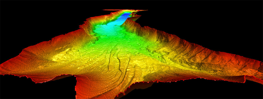
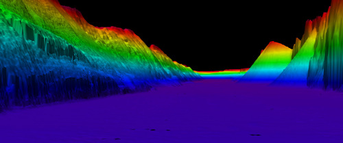
 During the exhibition it was highlighted how a three-dimensional morphology of the bottom, obtained thanks to a precise bathymetry, allows the simulation of deep and surface currents, thanks to which information is obtained relating to the distribution of temperature, the dynamics of the waves, the diffusion bacteria, pollutants and algae.
A first analysis of the three-dimensional bathymetric model of the Garda basin also showed a complex geological structure with craters, canyons, furrows, but above all it highlighted a fault between the locality of Sirmione and Punta San Virgilio whose existence was known only for the local geological dynamics, but which had never been identified with this resolution.
The processed model of the IIM is therefore the fundamental infrastructure for all those study activities related, for example, to environmental risks, geological analyzes, tourism, risk assessment in favor of the population of the Basin and civil protection. The acquired data represent a flexible database that can be used for the most disparate research and study activities, and will also allow the creation of a bathymetric map of Lake Garda, which will be included in the nautical documentation catalog published by the Hydrographic Institute of the Navy.
 Over the years, the IIM has fielded its own team of highly specialized personnel, a hydrographic boat equipped with the most modern detection equipment available, which operated in the three-year period 2018-2020 for a total of 96 days, I comprise an area of 371 Km2 covering 1500 nautical miles of sounding.
In summary, the collaboration between the Hydrographic Institute of the Navy and the Catholic University represents an excellent example of synergy in scientific research, which strengthens the dual capacity of the IIM even in non-marine environments, the result of which, the three-dimensional bathymetric model developed by the Institute's hydrographers it represents a fundamental element for the protection of the lake environment and consequently for all the activities that gravitate around the Garda basin.