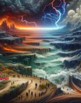
In these days, as every year, the news of out-of-control fires, often malicious, mercilessly destroying our forest heritage, crops and pastures, are all over the newspapers. Images of Canadair and firefighting teams engaged to the end of their strength appear continuously on the national news, as if to say: we are doing everything possible ... but is this really the case? Or could more be done?
My feeling, and that of many friends, without taking anything away and in support of those who fight on the field, is that it is possible to do more and better, especially from a political point of view.
In recent years, technologies have been developed that, if used correctly, can be of help to those who fight fire every day on the ground.
We are not experts in fires but like many of you readers we love our land, Sardinia, Sicily, Italy ... and we cannot remain indifferent to what happens.
 A few weeks ago some of us were in Cuglieri, greeting one of the oldest trees on the planet, a millenary olive tree that no longer exists ... we never thought we would probably be the last to see it in all its glory!
So, we decided to talk, to make our small contribution to this "war" that sees nature on one side and man on the other. traits of willful misconduct, many of the summer fires are most likely caused by man.
So it is as men that we want to try to make our contribution and technology can help us. In this article we want to address the issue of fighting fires through the use of technologies and we do it by talking about it with Pietro Andronicusfounder of Nurjana Technologies.
Who is Pietro Andronicus and what does Nurjanatech do?
I am the CEO and one of the two co-founders of Nurjana Technologies, a small Sardinian company that deals with new technologies, space technologies, decision support systems and much more, including intelligent predictive systems and we also love our land and we want to make a small contribution to the discussion. We started our journey in three and now a few years later we are twenty.
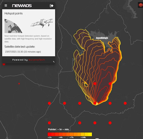
Among our projects there is one of particular interest for the prevention of forest fires. It is called S2IGI (Integrated Satellite Fire Management System). The project was also carried out thanks to European funds, through the Sardinia region. Thanks to the processing capacity of data collected through different types of sensors, including satellite images and data, our S2IGI is able to identify the onset of a fire within the first five minutes of ignition. At this point, the algorithms used make it possible to analyze the meteorological data and the "fuel maps" of the affected area and make a forecast relating to the development of the fire in the following thirteen hours, indicating the most probable behavior of the fire front and therefore the areas most affected.
Thanks to the collection of data from possible sensors and the possibility of integrating manual data (for example data relating to the last years of fires) it is possible to use S2IGI as a decision support system, i.e. a system that helps operators and decision makers to process the best strategy to act on the fire. The system is also useful in post-event analysis, to understand what happened and which factors influenced the development of the fire or its correct control.
 Pietro, your company is small but very enterprising. Among your collaborations you can boast several research centers around the world. Among these, we know that you have worked, precisely in the fire sector, with Australia.
Yes, very true. In recent years we have worked hard to improve algorithms and system in general, both in Italy and abroad. We are collaborating with the School of Aerospace Engineering of the Sapienza University of Rome, with the Institute of Bioeconomy of the CNR. In Australia we collaborated with the Commonwealth Scientific and Industrial Research Organization (CSIRO).
Starting from the technical - scientific results achieved with the S2IGI project, our NewMos system (Nurjana Eeath Wildfire Observation SystemI) was born with which we started a phase of validation of the solutions implemented by exploiting some historical data that have been made available to us in the region Sardinia, Piedmont and Liguria, but also in Portugal and Australia. The system has also processed in real time the data detected during the last fires that occurred in Sardinia and if the analysis of the post-event results confirms the reliability we intend, shortly, to release a demonstrative version of the system accessible so that you can have the immediate confirmation of the elaborations carried out during the events.
How do you get the satellite data you need for your analyzes? Are there any sharing or cost problems? What are fuel maps?
No, in principle there are no problems and, up to now not even costs, this is because we have the possibility to use them for research purposes, it would be different if we had to render a service. In this case we will have to pay to have access to the data.
The fuel maps are maps that are created thanks to the information available on the territory and take into account the different types of cultures present on the ground, in particular the wooded surfaces. The more the maps are updated the more correct are the system predictions. Often, in fact, the first problem of the operators is related to the scarce or outdated information about the land. It would be very useful to have up-to-date information, which is often obtained from locals, mushroom hunters, shepherds or landowners. Having the ability to integrate all this data, even manually, into a single decision-making system can make a difference.
Does your system also allow you to create a forecast model of the correct shutdown strategy? To be clearer, it is possible to understand through hypotheses, what is the best way to operate on a specific fire?
Yes, it is possible to make predictions by verifying the development hypotheses of the fire front and, thanks to the information of the fuel maps and the so-called "exposed" ones, understand how it is best to behave. As I said before, the forecast model works well but the map data is not always up-to-date. This means that if wrong information is given to the system, the forecasting model will give wrong information on the development of the front. But if the information is correct, the model is accurate enough to allow operators and decision makers to make the right decisions.
Most important, as always, is the close interaction between all parties involved. Also for us and for the future of our system, working closely with operators and decision makers can make a difference.
Returning to the past, we are told that to fight a fire it would be necessary to do as is done in buildings with fire doors. At one time you could see the fireproof strips made to prevent it from spreading without control over very large surfaces in the event of a fire. Do these practices still exist?
I am not an operator so I don't want to do their job. However, I can say that the knowledge of the presence of fire barrier strips can help to predict the development of the fire front. But as I said before, you need to have information that is as precise as possible and this is not always available in time.
Can the system also be useful for investigations? Can it help identify responsibilities? To be clear, we all know that telephone operators collect data on the presence of devices connected to the network and keep it for sufficient time to allow accurate investigations. Overlaying the data of access to the telephone network or the presence of a car in a certain area where the fire later developed could be of great help to the authorities.
In principle, this is the case, it is possible to exploit the technology in many ways. Our system allows you to analyze many factors, both in advance and a posteriori, based on the data collected, on the maps, on data available in the specific event or, if necessary, by integrating other data.
To conclude, in thanking Pietro Andronicus, hoping that the system will be useful in saving what remains of our forest heritage, we remind you that the fires are usually concentrated in two or three months, June, July and August. This means that the rest of the year can be used for other activities, such as prevention and information. In the field of prevention we can certainly say that the control of the territory and its preparation for the reduction of the risk of fire are part of it.
On the information front, it comes naturally to us to remember that in the event of a fire it is more useful to call 1515 immediately rather than filming and publishing the video on social media. In fact, remember that an early alarm sometimes makes the difference, especially when you are in areas far from inhabited centers and in the presence of wind.
We are all convinced of the need to do something to avoid events of this type, in our small way we do it by providing information.
Our proximity to the operators in the sector and to the affected populations.
Alessandro and Francesco Rugolo, Danilo Mancinone, Orazio Russo, Giorgio Giacinto
To learn more:
- Nurjana Technologies | Systems for Defense and Aerospace Market | Italy ;
- Commonwealth Scientific and Industrial Research Organization, Australian Government - CSIRO
- S2IGI - Integrated Satellite Fire Management System (nurjanatech.com)