The competition in the military between China and the United States continues at an incessant rate. And it's not just about classic weapon systems like hunting stealth fifth generation J20, recently presented at the most important Chinese aviation salon, the only product in the world that can compete with US aircraft.
Beijing now also looks at the capabilities of C2 and "situational awareness".
Proof is the recent acquisition from Luciad, a company in Leuven (Belgium) active in the defense sector, the world's most advanced real-time data analysis and management software, used not only by NATO commands but also by the United States Special Operations Command of Tampa (USA), the same coordinator the operation that led to the killing of Bin Laden.
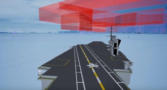
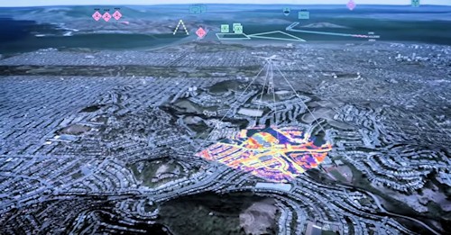
The package in question, called "Luciadlightspeed", includes a program for the analysis of real data coming from the operating environment able to provide an absolute "situational awareness", assured not only by physical data coming from the environment but also from the situation coming from moving objects, on the ground or in flight, including those for data acquisition.
The knowledge of the operating environment that results from it allows planners and analysts to conduct the decision-making process in support of the commanders on land in the most adherent form possible to the changes imposed by the evolution of the current situation.
 The validity of the software Luciadin fact, it is precisely in its accuracy.
According to the South China Morning Post, which reports the source of the American Graphics Technology Company Nvidia, "Luciadlightspeed" (see video) can process data from drones, satellite images, radar, aerial and ground sensors, but also weather forecasts and data from troops on the ground, at a speed of calculation and analysis equal to 75 times that of the other "competitors" and with an accuracy within 3 cm.
China has one of the largest networks of intelligence acquisition systems in the world, with sensors everywhere, even in front of the coast of Canada1, where recently some "devices" have been placed for the scientific study of oceanic wave motion.
Luciad is a brand founded in 1999 by a NATO engineer, Lode Missiaen, convinced that it was necessary to develop a product able to merge geographical information and data real-time in one product.
Boeing, Airbus Defense and Space, Lockheed Martin and Thales are just some of the customers that today use the software, whose property was recently acquired by Hexagon2, a Swedish brand.
1https://www.scmp.com/news/china/society/article/2169474/canada-installs-...
2https://www.hexagongeospatial.com
(photo: Hexagon AB)