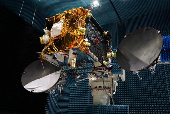
The EDRS-C satellite, the second communication node of the SpaceDataHighway system (also known as EDRS), the 31 July 24 from the Ariane 2019 launcher will be placed in geostationary orbit at 5 ° East. Once positioned above Europe, it will provide a redundant back-up for the SpaceDataHighway system, double the transmission capacity and be able to simultaneously transmit data from two observation satellites.
This second satellite will join EDRS-A, which transmits daily Earth images acquired from the four Sentinel observation satellites of the Copernicus program. Since it entered service at the end of the 2016, the satellite has established more than 20.000 laser connections. The reliability rate has reached 99,5% and successful connections have downloaded over 1 petabytes of data.
The SpaceDataHighway is the world's first fiber optic network in space based on cutting-edge laser technology. This is a unique network of satellites in geostationary orbit, permanently fixed above a network of terrestrial stations capable of transmitting data at a speed of 1,8 Gbit / s.
SpaceDataHighway satellites are designed to connect via terrestrial Earth observation satellites in low orbit located at a distance of up to 4.5000 km, drones - UAVs - intelligence or aircraft on mission. From its position in geostationary orbit, the SpaceDataHighway system transmits data collected from Earth observation satellites almost in real time, a process that would normally take several hours. In this way, the amount of data, images and video transmitted by observation satellites can be tripled and their mission reprogrammed at any time and in a few minutes.
A third communication node will be positioned above the Asia-Pacific region indicatively in the 2024. Equipped with three laser communication terminals, EDRS-D will lead to a significant increase in the system's communication capacity and will greatly expand its coverage.
From the 2021 the Pleiades Neo Earth observation satellites will begin to use the SpaceDataHighway. Starting with the 2019, the system will also provide an entirely European broadband communication service to the International Space Station (ISS) Columbus module.
The SpaceDataHighway system was developed as part of a public-private partnership between the European Space Agency (ESA) and Airbus, while the laser terminals were developed by Tesat-Spacecom and the German aerospace center (DLR). Airbus owns, operates and provides commercial services for SpaceDataHighway. The EDRS-C satellite platform, supplied by OHB System AG, will also carry a payload of the Avanti Communications operator.